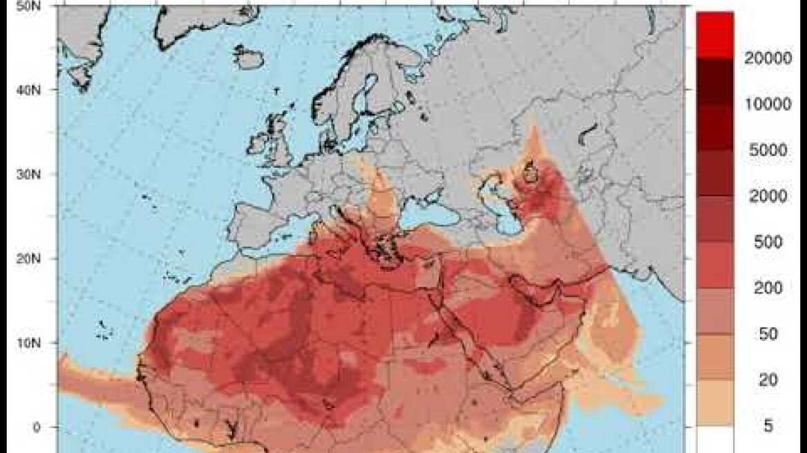
Its concentration will increase African dust According to the National Meteorological Service (EMY), the temperature is expected to rise gradually in the next few days in our country.
Especially, tomorrow SaturdayUsually there is a clear o Weather In the north, but gradually thin clouds will form, which will thicken from midday in the south and there will be mainly localized rain Peloponnese And Western continent.
Watch the video for Meteo Maps showing the trend of African dust through Tuesday:

“Cocktail” is significant High temperature And African dust Meteorologists have predicted a subtropical cyclone approaching Greece. Temperatures range from 30 to 32 degrees in many areas. Inland in the south and in Crete 34 to 36 degrees can be reached along with the southeast. Dust has a strong and constant presence in the country’s atmosphere, contributing to the feeling of discomfort.
Extreme events move mainly between Crete and the Peloponnese, while they gradually move further east. At noon, African dust is expected across the country, mainly in the west and south, and in the evening the dust will move to the central Aegean region.
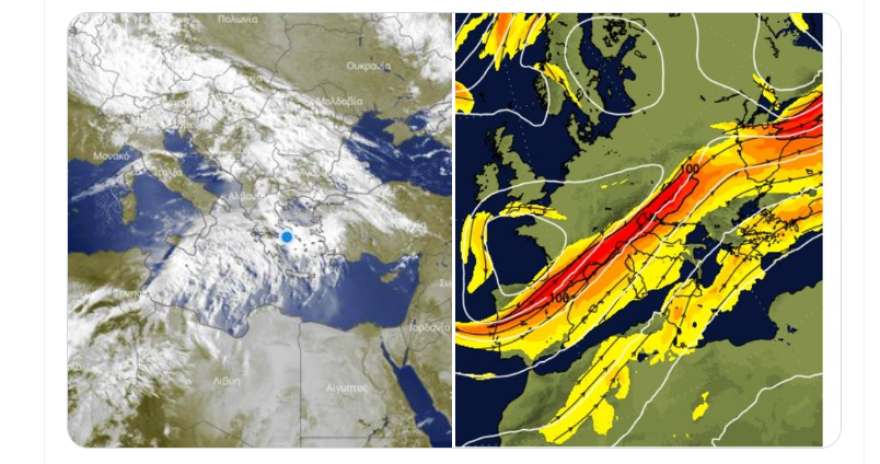
According to Totoris Kolitas earlier explanation the events are accumulated by air currents. “Created by a combination of atmospheric heating and the rotation of the planet on its axis. This upper flow of the atmosphere, along with nearly hurricane-force southerly winds blowing to the west, will cause the transport of African dust, but also high temperatures in our region until early next week.”
Thodoris Kolitas explains the air torrent phenomenon
1. #Windstorm is the main driver of weather systems which moves with its flow, we liken it to railway tracks along which weather wagons move.
2. In this case, hot masses and dust are transported, but at the same time there is cloudiness, which plays a preventive role in temperature rise (for now). We had informed about this in the past days but this information did not spread to the entire population
3. Many times (as we see in the picture) unstable weather forms between the two axes of the #jet stream. We mentioned in the previous post that this weather will mainly affect the north till Monday.

According to EMY, there will be extensive weather on Saturday
Initially, there will be generally clear weather in the north, but gradually in the south there will be thin clouds that will thicken from noon and there will be local rain or showers, mainly in the Peloponnese and western Styria. Visibility will be locally low during the morning hours over continental areas. African dust concentrations are mainly elevated in the west and south of the country.
Winds will be variable and weak, blowing east southeast 3 to 5 Beaufort in the Ionian and the same intensity in the Aegean northwest. Temperatures will rise slightly, mainly in the north. It ranges from 27 to 31 degrees Celsius in the mainland, 24 to 27 degrees Celsius in the island nation and 31 degrees Celsius locally in Crete.
Macedonia, Thrace
Weather: A few clouds gradually thickening from the west.
Winds: Variable to weak and easterly 3 to 4 Beaufort.
Temperature: 13 to 27 degrees Celsius.
Ionian Islands, Epiros, West Styria, West Peloponnese
Weather: Temporarily heavy scattered clouds in the south with localized showers or rain from afternoon.
Wind: Southeast 4 to 5 and locally 6 Beaufort in the Ionian. From afternoon southerly wind will turn to northeasterly direction with same intensity.
Temperature: 18 to 31 degrees Celsius.
Eastern Styria, Evia, Eastern Peloponnese
Weather: Scattered clouds thickening during the day, with local showers mainly in the Peloponnese.
Wind: 3 to 4 Beaufort from the East.
Temperature: 19 to 29 degrees Celsius.
Cyclades, Crete
Weather: Scattered clouds will thicken temporarily.
Winds: Northerly 3 to 4 Beaufort turning east with same intensity in the evening.
Temperature: 19 to 27 and locally up to 31 degrees Celsius in Crete.
Eastern Aegean Islands – Dodecanese
Weather: Scattered clouds will thicken temporarily in the south.
Winds: North-Northwest 3 to 5 Beaufort and South Westerlies 4 to 5 Beaufort.
Temperature: 17 to 29 degrees Celsius. 2 to 4 degrees decrease in the north.
Thessaly
Weather: Scattered clouds will thicken temporarily.
Winds: Variable 2 to 4 Beaufort and from noon to easterly with same intensity.
Temperature: 17 to 26 degrees Celsius.
Attica
Weather: Chance of thick clouds and light localized rain from noon.
Wind: Variable 2 to 3 Beaufort and 3 to 4 Beaufort from southerly direction in the afternoon.
Temperature: 18 to 28 degrees Celsius.
Thessaloniki
Weather: Partly cloudy.
Winds: Variable 2 to 3 Beaufort and temporary southeasterlies with same intensity at noon.
Temperature: 16 to 25 degrees Celsius.
Forecast for Sunday (19/5)
In the north, clouds increased temporarily, mainly in the afternoon and afternoon with local showers and isolated storms mainly in the mountains and gradually progressing. Elsewhere in the country, dense clouds will be seen during the afternoon and afternoon hours and concentrations of African dust will be high in most parts of the country.
Winds will be continental variable 3 to 4, easterly to 5 in the Ionian, northerly 4 to 5 in the Aegean and inland up to 6 Beaufort. The temperature does not change significantly. It reaches continental 28 to 30 and in places, mainly in the west, from 31 to 33 degrees, in the Cyclades and the East Aegean islands from 24 to 27, Crete, the Ionian Islands and the Dodecanese from 28 to 30 degrees Celsius.
Forecast for Monday (20/5)
Clear weather with occasional thick clouds from afternoon and west. There will be localized showers over northern continental areas and isolated storms over mountains during the afternoon-afternoon hours. African dust concentrations are high in most parts of the country.
Winds will be 3 to 5 in the West East Southeast, gradually increasing to 6 Beaufort in the Ionian. In the east, 3 to 5 winds will blow from northerly directions and 6 Beaufort winds will blow inland in the Aegean. Temperatures will rise slightly, mainly in central and southern regions. It reaches 28 to 32 degrees in the continent and 33 to 34 degrees in the west and south. It will be 27 to 29 degrees Celsius in the island nation, 32 to 33 degrees Celsius in Crete and the Dodecanese and 34 degrees Celsius inland.
Forecast for Tuesday (21/5)
In the north, a few clouds are forecast, mainly in the afternoon and afternoon with a chance of local showers, mainly in the mountains, increasing temporarily. Elsewhere in the country, clouds are hovering. African dust transport will be maintained.
Winds will be westerly from southerly 4 to 5 and will gradually turn westerly at 5 Beaufort in Ionian Local 6. In the east they blow northerly 3 to 5, gradually southerly to Aegean 6 Beaufort. The temperature does not change significantly.
Forecast for Wednesday (22/05)
Generally clear weather with moderate clouds in the center and south, thickening from the afternoon.
Visibility will be low locally during westerly, mainly continental mornings. African dust transport will be maintained.
Winds 3 to 5 NW in the West, Central and Southwest and 6 Beaufort in the southern seas inland. In the remaining regions, 3 to 4 Beaufort variables are present. Temperatures will drop slightly, mainly in the west and north.
News Today:
Kassalakis pets the dog, shakes his hand, wipes himself…cursing the first theme again – new post on social media
“I killed my partner because he raped him” – 51-year-old jailed for cold-blooded murder in Stavropol
Two MIT brothers ‘crack the code’ of Ethereum and steal $25M in crypto in seconds


More Stories
Acrylic vs. Must-Have Acrylic Brushes for Perfect Nail Art
Technological Advancements in Tortoise Tracking and Monitoring
Criminal gang in Mykonos encouraged women into prostitution – how they set up romantic dates