
As August awaits a second round of bad weather, residents in many parts of the country are worried about problems caused by heavy rains (Ioannina/epiruspost image above) and lack of flood protection works.
Yesterday, in fact, a message was sent from 112, with which residents of Patras, Ikomenitsa, Corfu and Ioannina were notified that extreme events would continue until the early hours of Tuesday.
Tuesday’s forecast calls for “high frequency lightning” and “localized hail in the west, center and north”.
⚠️ Implementation 1⃣1⃣2⃣
🆘 A severe weather warning for your area will continue until noon tomorrow
ℹ️ https://t.co/mbLpAekqgN@Pyroswestiki@Hellenic Police
— 112 Grease (@112grease) August 19, 2024
In EMY’s emergency bulletin, heavy rain and storms are forecast for Macedonia, Thrace and possibly Thessaly today, Tuesday.
In particular, localized showers and storms are forecast in the west, center and north, with locally high frequency of lightning and localized hail.
In more detail: Heavy rain and storms are forecast for:
A. Early in the morning in the northern Ionian (mainly in the area of Lefkada and Kefalonia), western Styria and Epirus
B. In central and eastern Macedonia and northern parts of Thessaly, it will gradually weaken from the morning to the afternoon.
Watch weather progress live
According to the director of EMY, Thodoris Golitas, the amount of rain was not high for 6 hours during the two days of the emergency declaration, but the pace of events locally is high.
Rain next day
The amount of rainfall per 6 hours is not particularly high for the two days the emergency bulletin is in force, but the pace of events inland is high. #Emergency #Storms@EMY_HNMS @CivPro_GR @Wikileas @Pyroswestiki@Starchannelnew1 pic.twitter.com/Cz2mhoHV3V— Theodoros Kolitas (@kolidasti) August 19, 2024
Alarm in 5 areas
Meteorologist Clearkos Marousakis spoke of an organized “wave” of bad weather, predicting that the bad weather would last until Thursday. Today, Tuesday, according to the meteorologist, Northern Ionian, Epirus, Thessaly, Central Macedonia and Thrace will be affected during the noon and afternoon hours.
Klearchos Marousakis called for attention to lightning, while on Wednesday he said bad weather would affect the rest of the country and Crete. He added that the possibility of rain is serious in central and northern Attica.
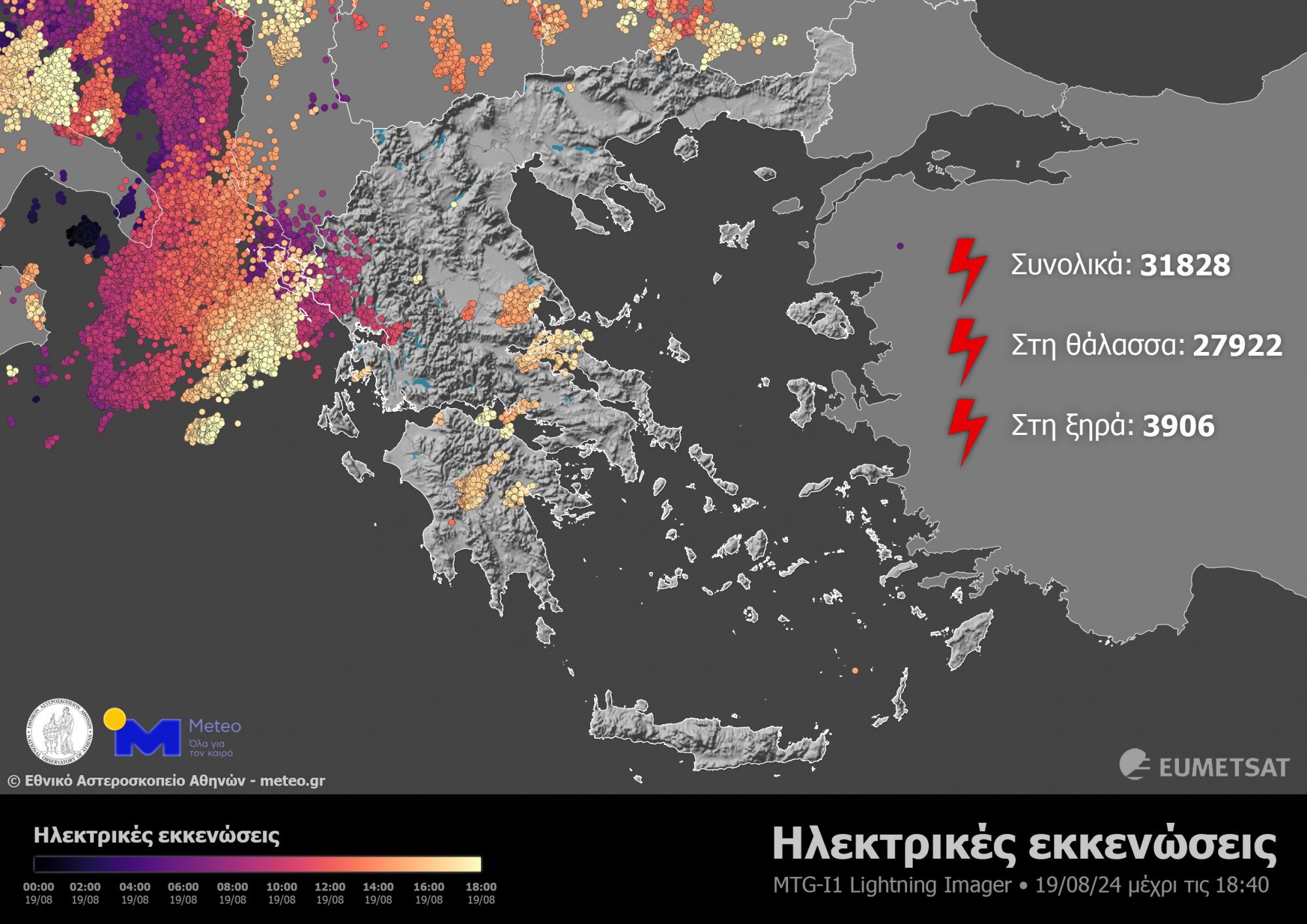
More than 30,000 lightning bolts
On Monday, rain and thundershowers accompanied by heavy currents lashed some parts of the country.
As of 18:40 yesterday, 31,828 discharges were recorded, of which 3,906 were over land and 27,922 over seas, according to the National Observatory of Athens/meteo.gr, which processed data from the third-generation European weather satellite MTG-I1. Instrument for real-time recording of electrical discharges (lightning and lightning).
Bad weather cleared
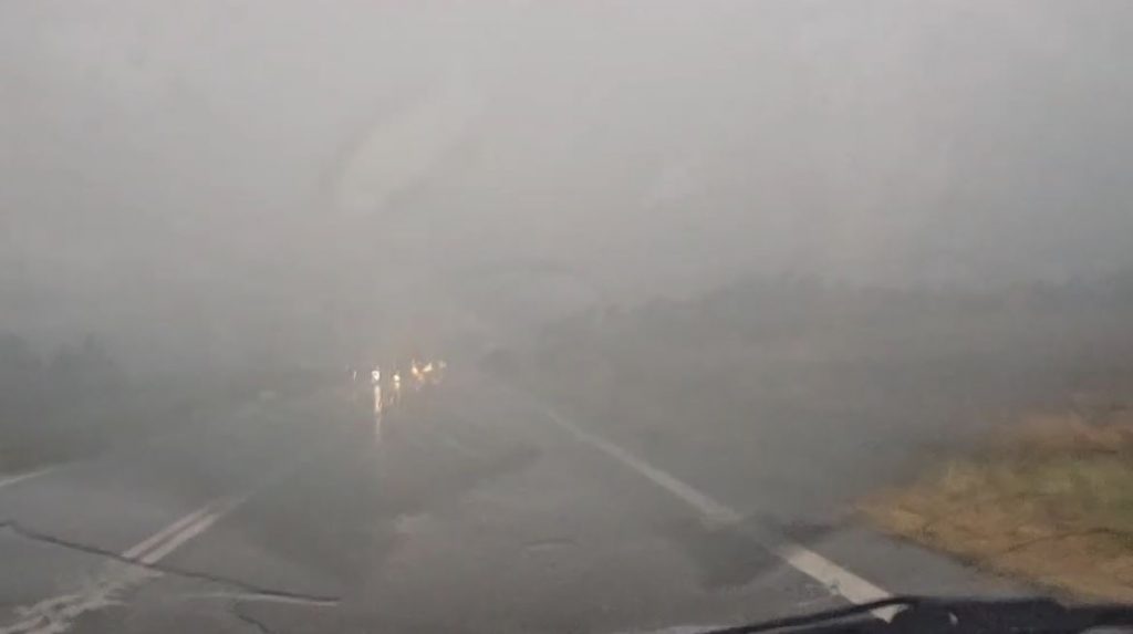
Heavy rains began on Sunday in western and northern Greece, such as Ioannina.
Roads turned into rivers, cars stopped in the middle of the road, roofs were torn off by strong winds, trees fell on roads and houses in low-lying areas of the city were flooded.
The biggest problems were in Archbishop Macario, Voianu and Garivaltis streets. Suburbs such as Perama and Neochoropoulos were also affected.
No electricity, crop damage
Roads were also flooded in northern Greece, while the villages of Bella were left without electricity due to lightning, where fires even broke out. There was heavy damage to crops in Kosani. In particular, acres of tobacco, vegetables, peppers, tomatoes, melons and watermelons were affected by hail in Aliagmonas and Galloneri.
Crops suffered heavy damage in Gosani
A wave of bad weather passed over Gozani too
According to local media, parts of Veria, Gilgis and Thessaloniki were “submerged” in water yesterday.
EMAK’s team visited Corfu
In Corfu, streets were flooded in Liston and Spianada, and there were problems with flights due to lightning. There was a brief power outage in many parts of the island, and traffic chaos at the city’s entrances.
In this context, a three-man team from the 5th EMAK rushed to the island on Monday afternoon to reinforce the local fire service.
EMY forecast for Tuesday today
Today, inland heavy rain and storms are expected in central and eastern Macedonia, the northern Ionian Sea, western Styria and northern Thessaly. Local showers and storms occur in other continental areas, mainly in the afternoon.
An improvement is expected in the evening hours. Generally clear weather in the Aegean region. Winds will vary from 3 to 4 and gradually southwest to 5 Beaufort.
For today, EMY warns of heavy rain and storms locally in central and eastern Macedonia, northern Ionian, western Styria and northern Thessaly.
The temperature will drop slightly in the northwest. Temperatures will range from 30 to 32 degrees Celsius in the northwest and 33 to 36 degrees Celsius in the rest of the country.
Macedonia, Thrace
Weather: Partly increasing clouds mainly in the afternoon with localized showers and isolated storms. Events in central and eastern Macedonia will be strong locally. Progress in the evening.
Wind: Variable 3 to 4 Beaufort.
Temperature: 20 to 33 and up to 35 degrees Celsius in Thrace. Minimums will be 3 to 4 degrees lower in western Macedonia.
Ionian Islands, Epiros, West Styria, West Peloponnese
Weather: A few clouds with localized showers and isolated thunderstorms increased temporarily mainly during the afternoon. In the northern Ionian (mainly in the area of Lefkada and Kefalonia), the events in western Styria and Epirus are locally strong. Progress in the evening.
Wind: 3 to 5 Beaufort from the South.
Temperature: 22 to 34 degrees Celsius. At least 3 to 4 degrees lower in the interior of Epirus.
Eastern Styria, Evia, Eastern Peloponnese
Weather: A few clouds with localized showers and isolated thunderstorms increased temporarily mainly during the afternoon. Progress in the evening.
Wind: Variable 3 to 4 Beaufort, gradually SW inland to 5 Beaufort
Temperature: 21 to 36 degrees Celsius.
Cyclades, Crete
Weather: Generally clear.
Wind: Variable 3 to 4 and gradually west inland to 5 Beaufort.
Temperature: 23 to 35 degrees Celsius.
Eastern Aegean Islands – Dodecanese
Weather: Generally clear.
Winds: Northwest 3 to 4 Beaufort and gradually 5 Beaufort inland in the western parts of the Dodecanese.
Temperature: 22 to 36 degrees Celsius.
Thessaly
Weather: Some clouds increased temporarily, mainly in the afternoon, with localized showers and storms. Effects in northern areas may be stronger inland. Nocturnal progress.
Wind: Variable 3 to 4 Beaufort.
Temperature: 20 to 36 degrees Celsius.
Attica
Weather: Some clouds increased temporarily in the afternoon.
Wind: Variable 3 and afternoon South to 4 Beaufort.
Temperature: 24 to 35 degrees Celsius.
Thessaloniki
Weather: Temporarily increasing clouds with localized showers and storms mainly in the afternoon and afternoon. Sometimes events are strong locally. The weather will clear in the evening.
Winds: Variable 3 to 4 Beaufort, evening northwesterly with same intensity.
Temperature: 21 to 31 degrees Celsius.

. “Professional creator. Subtly charming web advocate. Unapologetic problem solver. Devoted student.”


More Stories
Criminal gang in Mykonos encouraged women into prostitution – how they set up romantic dates
Earthquake in Kavtos: “Too early to decide if it’s significant” – Valleys closed, risk of landslides
Halkidiki – Luna Park: SKAI Revelation – Discovered by the Expert