Dangerous weather events Today Saturday (05-11-22) and tomorrow Sunday (06-11-22) will occur in some parts of our country, according to the National Weather Service’s new (updated) emergency bulletin of severe weather events issued Saturday morning.
According to EMY, Bad weather Eva -It already affects the northwest (North Ionian and Epirus)- Its main characteristics are the great height of rain, great speed and great frequency of lightning.
read more: What is the frozen mistral that bad weather Eva “savages”.
Additional information:
Today Saturday (05-11-2022) From the afternoon the strong and locally dangerous weather events that have already affected the northwest (northern Ionian and Epirus) will spread to southern Ionian, western Styria and western Peloponnese.
from the night Stronger effects will extend further east over eastern Peloponnese, central Styria, Thessaly, western and central Macedonia (including the city of Thessaloniki) and overnight eastern Styria (including Attica) and Evia.
her Sunday (06-11-2022) Heavy rains and storms will occur:
a) By noon in the Ionian Sea,
b) Afternoon on mainland (except Thrace),
c) From morning in Cyclades, Western Crete and Sporades
d) Afternoon in Samos-Ikaria region and Dodecanese regions
Attica
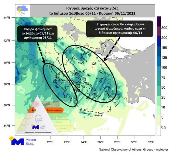
It is noteworthy that these events will be particularly intense in Central Macedonia, Thessaly, Sporades, Eastern Styria (including Attica), Eastern and Southern Peloponnese, and Western Crete.
The Attica Intermittent impact from Saturday night (05-11-2022) to Sunday (06-11-2022) afternoon.
According to the map published by meteo.gr, strong storms will begin to affect the province of Attica and the city and province of Athens on Saturday night and especially in the first hours of the shift to Sunday. City of Thessaloniki.
During the twelve hours from Sunday 06/11, strong events will be mainly in western, eastern and northern Greece and several island regions of the Aegean. During the second twelve hours of Sunday 06/11, the eastern and southern mainland, Macedonia, the central, eastern and southern Aegean and the islands of Crete will be significantly affected.
Events in Thessaloniki and Athens on Sunday 06/11 will be intense at times.
Watch the trend of bad weather live
Emergency update
As the representative of the fire department, Yiannis Artophios, said yesterday afternoon during the emergency conference on bad weather Eva, there is a strict recommendation to control the movement from civil protection, while depending on the events, messages from 112 will be sent. Citizens in other cases.
Referring to the National Meteorological Service (NMS), he stressed that the worst weather conditions are expected to hit gradually, from the morning onwards, with dangerous weather events that will have high altitudes as their main characteristics over most of the country. High frequency of rain, strong local winds and lightning.
He further said that all civil defense forces have been put on maximum alert and alert to face any flood emergency, while fire brigades have been deployed in areas where incidents are expected. Increased readiness and further expansion, if necessary, to deal with any problems promptly.
“We strongly advise citizens to be especially careful and closely follow basic self-protection measures:
- Limit your travel during severe weather to absolutely necessary
- Always remember to move to the highest places in the house in case of flooding.
- Do not cross flooded rivers, streams or roads on foot or in a vehicle under any circumstances if you find yourself in this location. Any reason.
- We also remind you that the emergency notification of dangerous weather events is updated every 12 hours and is available on the emy.gr website, as announced by the National Meteorological Service,” he added.

. “Professional creator. Subtly charming web advocate. Unapologetic problem solver. Devoted student.”


More Stories
Criminal gang in Mykonos encouraged women into prostitution – how they set up romantic dates
Earthquake in Kavtos: “Too early to decide if it’s significant” – Valleys closed, risk of landslides
Halkidiki – Luna Park: SKAI Revelation – Discovered by the Expert