%20(1).jpg?itok=D5Bd9pFx)
Maps have become more useful Google With the popular app now offering other valuable information to drivers who use it to navigate.
Google Maps tends to become an integral part of the daily life of those who are behind the wheel of their cars and those who use it using other means for their movements.
The famous application of the American company offers more and more information to its user and in this way makes navigation easier. And gives at the same time and An opportunity for those who take advantage of it to better prepare for their destination point.

In order to make its app more convenient and useful, Google is going ahead with another important update, this time only for mobile users using the Android operating system.
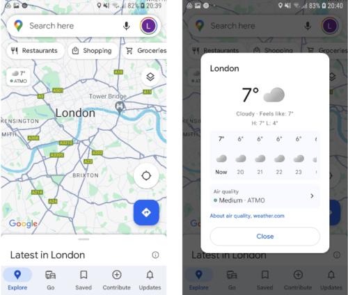
Specifically through information that started a few weeks ago around the world Americans are incorporating weather reports into Google Maps as well as information about the air quality in the area.
This information has been available to iOS device owners for years, and now, albeit with a relative delay, It is now also offered for Android users, who do not need to use additional apps for weather forecasting and air quality respectively.
After the update, which as we mentioned above is gradually happening around the world, when you open the application, Google Maps will display a small relevant icon at the top left of the screen, below the Find a Point of Interest bar.
The symbol appears In short, the ambient temperature in the area as well as the air quality Users who want more detailed information can get it with a touch on the icon (see related image) and see the weather forecast for the next 12 hours.
The information includes the lowest and highest temperatures in an area during specific time periods, But also forecasts of rain, clouds, etc.
Read also:

“Total alcohol fanatic. Coffee junkie. Amateur twitter evangelist. Wannabe zombie enthusiast.”


More Stories
Is this what the PS5 Pro will look like? (Image)
Finally, Windows 11 24H2 update significantly boosts AMD Ryzen – Windows 11 performance
Heart Surgeon Reveals The 4 Things He ‘Totally Avoids’ In His Life